An earthquake is a more or less violent shaking of the earth's crust resulting from the release of a large amount of energy in the lithosphere.
The Earth's crust is divided into several tectonic plates. These plates move a few centimetres a year as a result of the convection of magma within the mantle.
Since the lithosphere is mainly solid, when subjected to internal forces from the Earth, this part stores energy and gradually deforms. When the tension is too great, it ruptures. In short, when there is an earthquake, the ground will suddenly move from a few centimetres to several metres. The vibrations of the ground can then be felt. More precisely, an earthquake is the result of a sudden release of energy accumulated by the forces exerted on the rocks.
Earthquakes can be of natural origin (tectonic or volcanic) or man-made.
- Tectonic earthquakes are caused by the movement of tectonic plates. These are the most frequent and most devastating earthquakes. When two tectonic plates rub together, pressure is exerted on the rocks of the lithosphere. When the lithosphere has reached the limit of its elasticity, all the energy accumulated in the lithosphere is released, causing an earthquake. Earthquakes can also occur when two plates collide or move apart.
- Volcanic earthquakes are caused by the accumulation of magma in a volcano. They are generally the first signs of a volcanic eruption. These earthquakes cause less damage than those of tectonic origin.
- Man-made earthquakes are caused by certain human activities that disrupt the integrity of the lithosphere. The impounding of a large dam, gas extraction, seismic exploration, mining and quarrying, underground nuclear testing and the collapse of old mines are all examples of earthquakes caused by human activity.
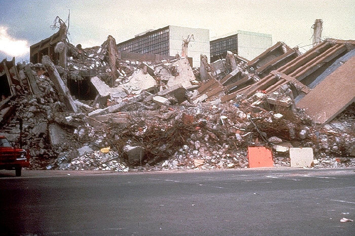
Example of the consequences of an earthquake.
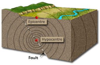
The focus of an earthquake is the place from which the vibrations of the quake originate. It can be very close to the surface or up to 700 km deep. This is where the earthquake actually takes place.
The epicentre of an earthquake is the point on the earth's surface that lies vertically above the focus. This is where the tremors are most intense and where the vibrations originate.
Regardless of the origin of the earthquake, very high pressure is exerted in the lithosphere. The vibrations caused by this pressure propagate in all directions. These vibrations are known as seismic waves.
The location in the Earth's crust where the seismic waves originate is the focus of an earthquake. It is sometimes called the hypocentre. This is the point in the rupture zone where the energy is released in full force. The most intense tremor will be felt at the surface opposite the focus. This location is called the epicentre of an earthquake.
Seismology is the science that studies earthquakes.
Earthquakes have long been regarded as divine messages. It was not until the 1600s that people began to regard them as natural phenomena. For a long time, earthquakes were based solely on observation, but it was not until the early 20th century that the science of earthquakes began to take shape. This science is called seismology.
The people who study earthquake phenomena are called seismologists. The instrument that measures and records ground vibrations is called a seismograph. The graph produced by the seismograph is called a seismogram.
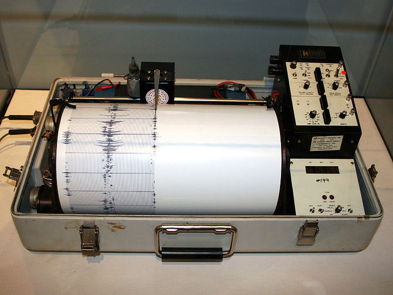
Sismographe
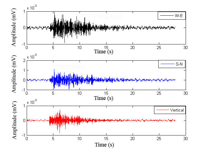
Seismogram
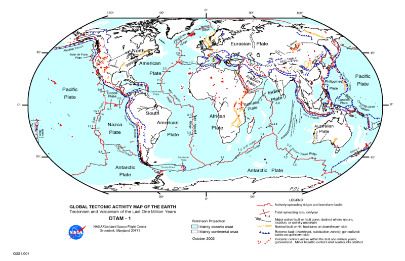
You might think that earthquakes occur just about anywhere on Earth, but that's not the case at all. The distribution of earthquakes supports the theory of plate tectonics. All the plates move in relation to each other. The vast majority of earthquakes occur at the boundaries of tectonic plates.
Map of areas of high seismic activity
Earthquakes occur in the divergence or spreading zones that give rise to oceanic ridges. These zones are the site of many relatively moderate earthquakes.
Earthquakes also occur in convergence and collision zones, which correspond to subduction zones. This is where we find the most violent earthquakes and those with the deepest centres.
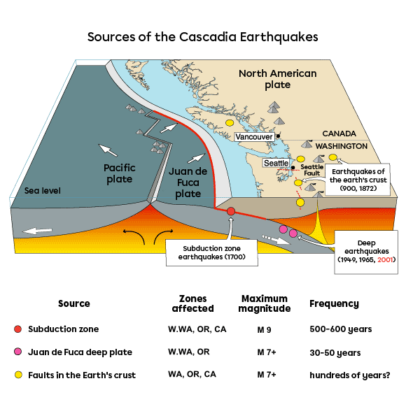
An example of a convergence zone is the boundary between the Juan de Fuca oceanic plate and the North American continental plate. This subduction zone is called Cascadia and runs deep south of Vancouver Island in Canada. As the diagram shows, it is the continent that is moving westwards and the oceanic plate that is sinking beneath it.
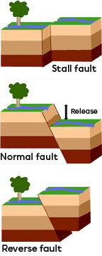
Earthquakes occur in slip zones, which are characterised by faults. Faults are plate breaks, and the two pieces of plate can slide over each other, causing earthquakes whose source is near the surface. There are three types of fault: the normal fault, which accompanies extension; the reverse fault, which accompanies compression; and slip faults, which accompany sliding movements.
Finally, zones of collision between continents are also zones where seismic activity can be found. There is also intraplate seismic activity, i.e. within the lithospheric plates themselves. Earthquakes associated with hot spot volcanoes are examples of this.
However, the earthquakes in the Charlevoix region of Quebec are continental intraplate earthquakes, but they are not linked to volcanoes.
Around 100,000 earthquakes are recorded around the world in any given year. The vast majority of these are not even felt by humans. There are several measurement scales used to determine the magnitude of an earthquake. Of these, the Richter and Mercalli scales are the most widely used in North America.
The Richter scale is the best-known way of measuring earthquakes. It is named after its creator, Charles Richter, who created it in 1935. The scale is generally graduated from 1 to 9, but an earthquake could exceed this value. The magnitude is calculated from the energy released from the focus. On the Richter scale, a one-unit increase in magnitude means a 10-fold increase in power. An earthquake of magnitude 6 is 10 times more powerful than one of magnitude 5, so an earthquake of magnitude 6 will be 100 times more powerful than one of magnitude 4. Since it is based on the energy released and not on the damage caused, the Richter scale can be described as objective.
| Description | Magnitude |
Effects |
Frequency |
| Micro | Less than 1,9 | Micro earthquake, not felt | 8,000 per day |
| Very minor | 2,0 to 2,9 | Generally not felt but detected/recorded | 1,000 per day |
| Minor | 3,0 to 3,9 | Often felt but rarely causes damage | 50,000 per year |
| Light | 4,0 to 4,9 | Significant shaking of objects inside houses, clattering noises. Unusual major damage | 6,000 per year |
| Moderate | 5,0 to 5,9 | Can cause major damage to poorly designed buildings in restricted areas. Causes minor damage to well-constructed buildings | 800 per year |
| Strong | 6,0 to 6,9 | Can be destructive in areas up to 180 kilometres away if populated | 120 per year |
| Major | 7,0 to 7,9 | Can cause moderate to severe damage over larger areas | 18 per year |
| Important | 8,0 to 8,9 | Can cause serious damage in areas hundreds of kilometres away | 1 per year |
| Devastating | 9,0 and more | Devastates areas thousands of kilometres around | 1 to 5 per century |
In North America, the modified Mercalli (MM) intensity scale is also used to quantify the degree of surface effect. The intensity of an earthquake, in this case, is determined by the extent of the damage caused by the earthquake and the population's perception of it. It is therefore a subjective scale.
|
Degree |
Extent of damage observed |
| I | No movement is perceived. The earthquake is only detected by sensitive instruments and a few people in special conditions. |
| II | Some people can feel a movement if they are at rest and/or on the upper floors of tall buildings. |
| III | Many people feel a slight movement inside buildings. Suspended objects move. Outside, however, nothing is felt. |
| IV | Most people feel movement indoors. Hanging objects move, as do windows, dishes, plates and door latches. |
| V | Most people feel the movement. People who are dozing are awakened. Doors slam, crockery breaks, pictures move, small objects shift, trees sway, liquids may overflow from open containers. |
| VI | Everyone feels the earthquake. People walk unsteadily, objects and pictures fall, plaster on walls may crack, trees and bushes are shaken. Slight damage may occur to poorly constructed buildings, but no structural damage. |
| VII | People find it hard to stand. Drivers feel their cars being shaken. Some furniture may break. Bricks may fall from buildings. Damage is moderate in well-constructed buildings, but can be considerable in others. |
| VIII | Drivers find it difficult to drive. Houses with weak foundations move. Large structures such as chimneys and buildings can twist and break. Well-constructed buildings suffer slight damage, while others suffer severe damage. Tree branches break. Hills can crack if the ground is wet. Water levels in wells can change. |
| IX | All the buildings were badly damaged. Houses without foundations move. Some underground pipes break. The earth cracked. |
| X | Most of the buildings and their foundations were destroyed. Some bridges were also destroyed. Dams were seriously damaged. Landslides occurred. Water was diverted from its course. Large cracks appear in the ground. Railway tracks bend. |
| XI | Most buildings collapsed. Bridges were destroyed. Underground conduits were destroyed. |
| XII | Almost everything is destroyed. The ground is undulating. Large chunks of rock can move. |
It is important not to confuse magnitude and intensity. The magnitude can be calculated, but the intensity is estimated. The magnitude is a value that we associate with the earthquake alone, whereas the intensity is associated with the place of observation. Two earthquakes can have the same magnitude, the same energy released, but not have the same intensity at the surface, and not have caused the same damage.
A tsunami is a series of ocean waves that are created by a movement in the ocean floor or by an earthquake.
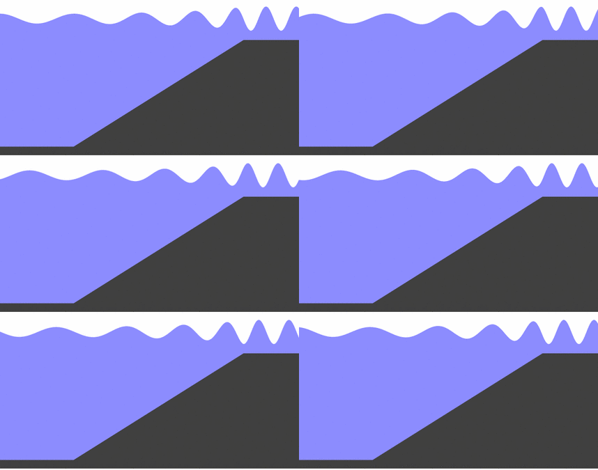
When an earthquake occurs in water, a large mass of water is displaced. In deep water, tsunami waves can travel at speeds of more than 800 km/h, but are no more than a few decimetres high. As these waves approach the coast, the speed decreases, but the amplitude becomes greater and greater: the waves can reach heights of more than 10 m.
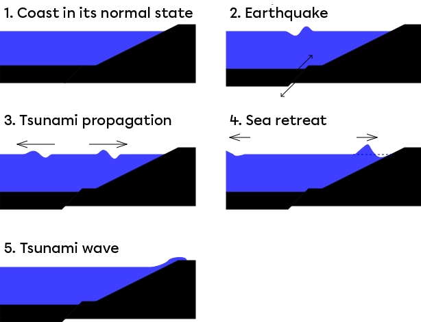
The tsunami is formed in five stages.
- First, the coasts are in their normal state.
- An earthquake occurs, creating a fault in the ground that leads to the formation of the first wave.
- The tsunami propagates on either side of the fault.
- The waves arrive close to the coast.
- The tsunami hits the ground.
The amplitude of tsunami waves depends on several factors, including the intensity of the earthquake. The level of subsidence of the ocean floor during the earthquake, the presence of natural barriers (such as coral reefs).
