To access the other concept sheets in the Cities Subject to Natural Hazards unit, check out the See Also section.
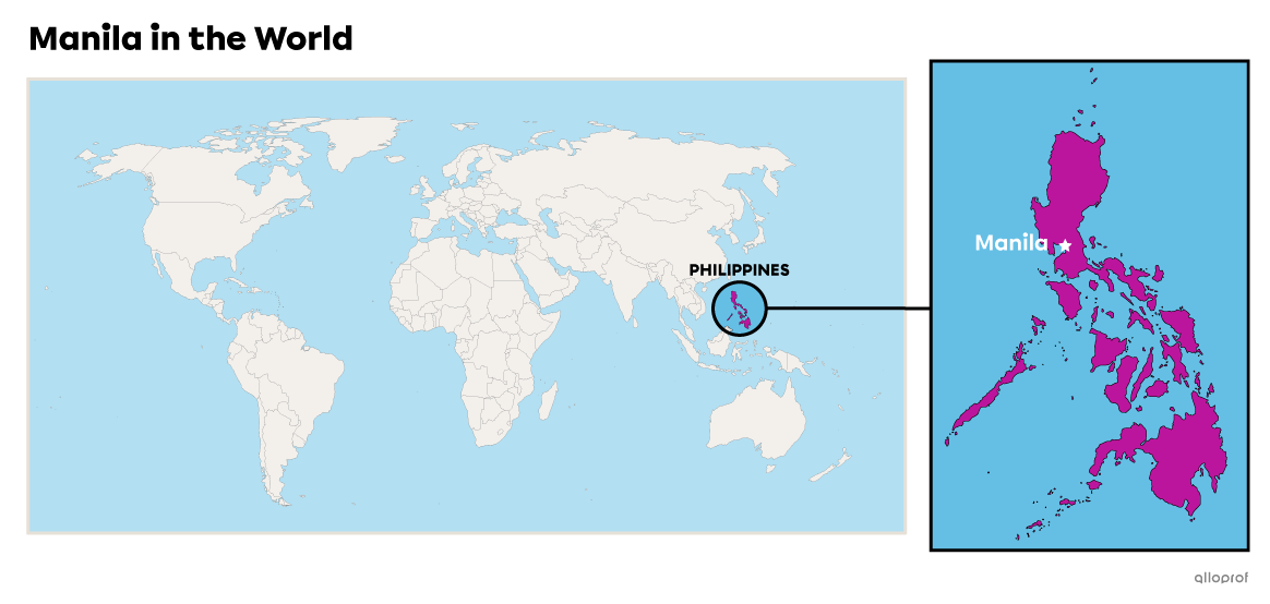
Manila is located on the continent of Asia, more specifically, in the Philippines. This country is an archipelago of 7107 islands[1].
The metropolis of Manila is the capital of the country. It is located on the island of Luzon, the largest in the archipelago. The city is on the western end of the island, on Manila Bay, and the Pasig River flows through it.
-
An archipelago is a group of islands.
-
A bay is a body of water partially enclosed by land but with access to a sea or a lake.
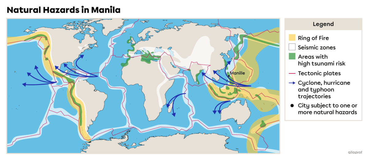
The Philippines is the third country in the world most exposed to natural hazards. As elsewhere in the country, Manila is located in a very high-risk area.
-
It lies along the Pacific Ring of Fire.
-
It is close to active volcanoes.
-
It is located on a very active fault, which produces many earthquakes.
-
It is located in a very high-risk tsunami zone.
-
It is located on the trajectory of typhoons.
-
It is crossed by the Pasig River, which represents a flood risk during heavy rainfall.
A fault is a break in the Earth’s crust.
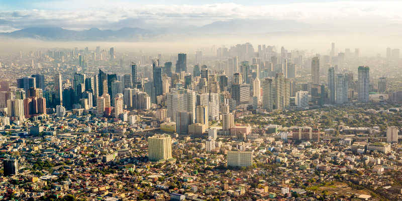
The capital region includes the city of Manila as well as what is referred to as Greater Manila. This is the name of the metropolis of Manila, which includes the neighbouring cities. Greater Manila covers an area of 633 km2 and has a population of approximately 13 484 462 inhabitants[2]. Consequently, its population density is 12,302 inhabitants/km2.
The city of Manila has an even greater population density. With an area of only 38 km2 and a population of approximately 1 780 148 inhabitants, its population density is 46 846 inhabitants/km2[2].
In comparison, the metropolis of Montreal has a population of 912 inhabitants/km2[3].
Manila’s high population density makes it a city that is particularly vulnerable to natural hazards because with so many people living there, natural disasters have greater human and material consequences.
-
Population density refers to the average number of individuals living in a given area. It measures the number of inhabitants per square kilometre (inhabitants/km2).
-
A natural disaster is a natural phenomenon that causes material damage (to buildings, roads, etc.) and human victims (injuries, loss of life, etc.).
Source: MDV Edwards, Shutterstock.com
The Philippines, where Manila is located, is a developing country. There is significant poverty there, despite many natural resources, such as gold, copper and silver. The gross domestic product per inhabitant (GDP/inhabitant) in the Philippines is approximately 4 times greater than the global average[4].
Approximately 26 million people live in poverty and nearly 12 million live in extreme poverty in the Philippines[4]. More than 4 million people live in slums[5]. These people are very vulnerable to natural disasters.
The natural disasters that occur in the Philippines are also the source of some of the country’s economic difficulties. Between 2013 and 2018, the country had two earthquakes and 49 typhoons, which cost almost $8 billion per year, or a total of $48 billion over the 6 years[6].
-
A developed country is an industrialized country where the population generally has a high standard of living.
-
Gross domestic product (GDP) is used to estimate a country’s wealth by calculating the value of the goods and services its produced in one year.
-
Poverty occurs when a person does not have enough money to ensure decent living conditions.
-
Extreme poverty occurs when a person does not have enough money to meet their basic needs, such as food, housing, etc.
-
A slum is a living area close to a metropolis where very disadvantaged people live. Slums have few or no basic services (water, sewers, electricity, etc.).
There are many earthquakes in the Philippines. Not only is the country located in the Ring of Fire, but the archipelago also sits on the boundary of the Philippines’ tectonic plate.
The metropolitan area of Manila faces a moderate earthquake risk unlike most of the country, which is at high risk. The inhabitants of Manila often experience earth tremors, but most of the time these are weak tremors caused by earthquakes elsewhere in the country.
However, Manila is not completely safe from a possible earthquake. The major seismic fault known as the West Valley Fault is located very close to the metropolitan area. While there has been no movement for approximately 400 years, scientists believe that it will eventually cause an earthquake.
With such a high population density, an earthquake in Greater Manila could cause between 31 000 and 35 000 deaths[7].
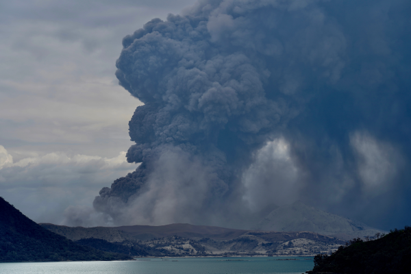
Manila is at a high risk of volcanic eruptions. The city is located close to two active volcanoes: Pinatubo, which is a little less than 100 km northwest of Manila, and Taal, 60 km to the south.
Taal is the second most active volcano in the Philippines. Because it is an explosive volcano, it expels clouds of ash and toxic gas covering many kilometres. It is the deadliest volcano in the country because it is located close to many inhabited areas.
Pinatubo is also an explosive volcano. In 1991, it erupted for the first time in more than 500 years. Its last eruption was in 1993.
Taal
This is a particularly active volcano and erupts more often than Pinatubo.
More than 135 000 people were evacuated from the risk zone when it erupted on January 12, 2020[8]. Ash, volcanic gases and rock fragments were projected more than 15 km from the site. Lava was spewed hundreds of metres into the air and lava flows buried dozens of houses. More than 450 000 people were affected by the disaster. Houses were destroyed, entire families were displaced and livestock and fields were lost[9].
In July 2021, even though there was no eruption, the volcano spewed toxic gases for several days. These gases covered Manila in smog. More than 2400 people were temporarily displaced. This toxic cloud put the lives of more than 300 000 people in danger.[8]
On March 26, 2022, Taal erupted again and ejected ash and vapour hundreds of metres into the sky. More than 12 000 people were evacuated, mostly from five villages around the volcano that are particularly vulnerable. This was the third time in three years these residents were evacuated[10].
Pinatubo
Pinatubo’s eruption in 1991 was one of the biggest eruptions of the 20th century, starting on June 15 and lasting until September 2. This disaster affected more than 2 million people and caused approximately 300 deaths[11].
Since the volcano was being monitored by the Philippine Institute of Volcanology and Seismology (PIVS), scientists were able to precisely predict the time of the eruption. Authorities were able to carry out mass evacuations before the eruption, saving tens of thousands of lives.
The material and economic damage was much greater.
-
There was $700 million in damages[12].
-
Entire cities and villages disappeared.
-
Fields and crops were completely destroyed by ash.
-
Houses, public infrastructure and transportation infrastructure were damaged or destroyed.
Today, Pinatubo is considered an asset for the region because it attracts many tourists who can climb the mountain and admire the crater.
Most of the Philippines is located in a high-risk tsunami zone while the metropolis of Manila is located in a moderate-risk tsunami zone. Although Manila has not experienced a tsunami in the last few years, it is nevertheless vulnerable.
Scientists have found evidence to prove that a tsunami in the past affected the area where the metropolis of Manila is now located. Movement of the Manila trench could trigger the formation of a tsunami.
Based on scientists’ tsunami prediction models, the time between the formation of a tsunami and the impact on the coastal region of Manila and the surrounding area would be only nine minutes. The waves could reach 16 metres in height. Consequently, it is important to put an effective prevention program in place for a future natural disaster of this kind.
Manila is in an area that is at high risk of typhoons. Indeed, approximately 20 typhoons per year affect the Philippines, and a significant number affect Manila[13]. They cause damage due to wind, rain and the floods that can follow. It is important that this risk be assessed in construction projects as well as in the city’s planning and development.
According to the Intergovernmental Panel on Climate Change (IPCC), the wind speed and the number of category 4 and 5 cyclones are expected to increase in the next few years due to global warming. This will make Manila even more vulnerable to typhoons.
This typhoon, called Rosing in the Philippines, hit the country between the end of October and beginning of November 1995. Angela reached Category 5 with winds of up to 190 km/h.
There were many consequences. According to the United Nations Office for the Coordination of Humanitarian Affairs, on November 13, 1995:
-
722 people had been killed
-
160 people had disappeared
-
2369 people had been injured
-
1 597 219 people had been affected
In terms of damage to housing:
-
147 999 houses had been destroyed
-
388 033 houses had been partially destroyed
The cost of lost crops was estimated at US$131 million[14].
Manila experiences two types of floods: coastal floods (high risk) and urban floods (moderate risk).
Coastal Floods
Coastal floods occur, as the name suggests, along the coast. In Manila, this occurs along the coastline of Manila Bay, which is connected to the South China Sea.
Coastal floods have a number of different causes, primarily:
-
waves
-
tides
-
storms, such as typhoons
-
variations in sea level
In Manila, coastal floods are mostly related to tropical storms and typhoons. In the longer term, the capital is threatened by rising sea levels due to climate change.
Urban Floods
Urban floods have a number of different causes, such as heavy rainfall due to monsoons. They also result from some of the same causes as coastal floods. What is characteristic of this type of flood is that the water cannot easily run off because much of the urban surface is impermeable. This makes it difficult to drain the water, which ends up accumulating in the city.
In Manila, the monsoon is a major cause of urban floods. During this rainy season, a lot of precipitation falls on the metropolis over a short period, leaving no time for the water to run off.
The monsoon is a seasonal wind in tropical regions that brings heavy precipitation (rain) for several months.
In early August 2012, Manila experienced heavy rainfall. Approximately 80% of the capital was flooded[15]. Many people had to use boats to get around the city streets.
The equivalent of one month’s rain fell in 48 hours.
Close to 2 million people were directly affected by this natural disaster[16]. Many of these people had to be given shelter and drinking water, and food had to be distributed.
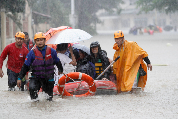
Source: Cheryl Ravelo, Alamyimages.fr
Landslides are a natural disaster. However, in Manila, and more generally in the Philippines, landslides are often a consequence of another natural disaster. Here are a few examples.
-
In August 2012, the monsoon rains caused landslides, including one in a slum north of Manila[17]
-
In December 2017, Tropical Storm Kai-Tak caused several landslides, killing more than 20 people[18]
-
In July 2022, a 7.1 magnitude earthquake caused more than a dozen landslides[19]
The metropolis of Manila is particularly vulnerable to natural disasters. As mentioned above, because it faces many natural hazards, it must be prepared to deal with all of them.
In general, the city of Manila and the Philippines have good disaster management protocols and are ready to deal with various environmental risks.
| Prevention measure | Example |
|---|---|
|
Informing part of the population of the risks and the measures to take before, during and after a natural disaster. |
Many of the city’s inhabitants are aware of the steps to take to find shelter during an earthquake: people who work or live in multi-storey buildings know that they must evacuate. |
|
Adapting infrastructure to be able to handle various disasters. |
Houses on Stilts Some people build houses on stilts in order to cope with floods caused by typhoons, rains and tsunamis. Source: Antonio V. Oquias, Shutterstock.com |
|
Implementing various measures to minimize the consequences of volcanic eruptions. |
|
|
Implementing various measures to minimize the consequences of waves caused by tropical storms and typhoons. |
Breakwater in Manila Breakwaters are built along the coast to minimize floods caused by powerful waves and typhoons. Source: Jomar Aplaon, Shutterstock.com |
|
Monitoring meteorological phenomena, such as floods and typhoons. |
The Philippine Atmospheric, Geophysical and Astronomical Services Administration (PAGASA) is responsible for several different preventive measures:
|
|
Monitoring earthquake activity, volcanic activity and tsunami risks. |
The Philippine Institute of Volcanology and Seismology (PHIVOLCS) is responsible for this monitoring. Source:Un sismographe du PHIVOLCS [Photographie], Alquinto, M. F., s.d., L’indépendant, (URL). Droits réservés*[22] |
The Philippine government established a new national organization with the primary goal of providing better prevention and response to natural disasters. The Philippine Space Agency (or PhilSA) was created in 2019 and uses space technologies to track and better manage natural disasters.
Among other things, the images provided made it possible to verify the distance travelled by lava and ash during Taal’s eruption in January 2020. The satellite images made available by this organization are also used by PAGASA to track meteorological phenomena.
There are many reasons for the economic difficulties in the Philippines. However, in the context of this unit, we focus on one: the chain of natural disasters.
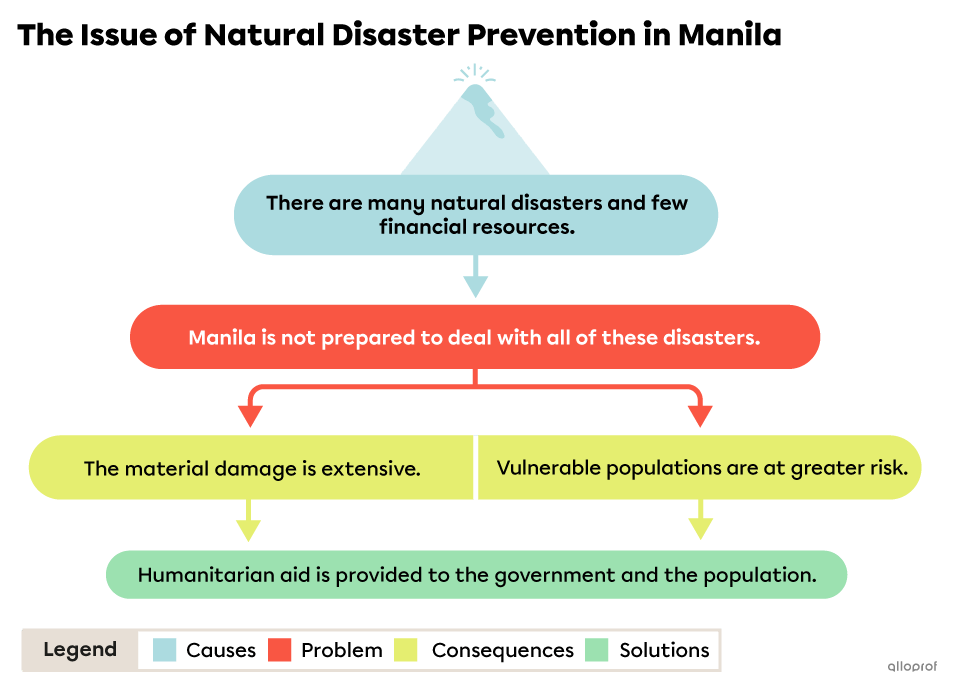
Natural disasters follow one after the other, making it difficult for the country and its cities to recover from these events.
The Philippine government is the main actor in preventing natural hazards from becoming disasters. However, the government lacks financial resources to do so.
In the Philippines, 74% of the population is exposed to various natural hazards. Between 1980 and 2020, the Philippines experienced:
-
276 tropical storms and typhoons
-
19 volcanic eruptions
-
28 earthquakes
-
136 floods[20]
Manila, and the Philippines more generally, are not very prepared to deal with natural disasters. The chain of natural disasters and the lack of money make it difficult to put adequate prevention plans and measures in place.
This problem has two major consequences:
Extensive Material Damage
The first consequence of a natural disaster is that there is extensive material damage because the authorities do not have the money and sometimes do not have enough time between natural disasters to fully rebuild and reinforce the infrastructure.
In the Philippines, from 2000 and 2012, natural disasters cost an average of $252 million per year[21]. The agricultural sector requires the most money, followed by infrastructure. Most of the natural disasters that affect the country cause enormous damage to fields, houses, infrastructure such as roads and aqueducts, as well as sewer and electricity systems.
| Natural disaster | Material and economic damage |
|---|---|
|
Typhoon Haiyan, which hit the country in 2013 |
|
|
The 7 magnitude earthquake that hit the province of Abra in 2022 |
|
Sources: Climate Change Knowledge Portal, n.d.[20], ONU Info, 2022[23]. |
|
Sometimes a lack of financial resources is not the problem, but rather how they are managed and distributed.
This was the case in 2022 after Tropical Storm Nalgae. The National Disaster Risk Reduction and Management Council recommended declaring a state of disaster. However, the country's president, after consultations with the Department of the Environment and Natural Resources, decided against this. The Department considered the damage to be too localized.
Declaring a state of disaster in a region makes it possible to free up funds for this type of situation and to freeze the price of goods.
More than 2 million people were affected by the storm and the material damage to infrastructure was evaluated at more than $18 million. The damage to the agricultural sector was evaluated at more than $9 million and the damage to housing was close to $300 000.[24]
The Difficulty in Protecting Vulnerable Populations
The second consequence is that the populations most vulnerable to natural disasters remain in situations of extreme precarity when there are insufficient resources and plans in place to help them.
Poor populations often live in slums, sometimes even when this is prohibited by the government. These places are often unsafe and dangerous, and the houses are often flimsy, which increases the risks to these populations in the face of natural hazards.
The government does not have the means to relocate these populations to safer areas, or to inform people of the risk and prevention measures to take in the event of a disaster.
The high frequency of natural disasters makes it even more difficult for the most disadvantaged populations to escape poverty.
Since the country lacks the resources needed to help disaster victims and to repair the infrastructure and adapt it for future natural disasters, the country must rely on humanitarian aid. This aid comes from international organizations and various countries.
This aid comes in the form of:
-
financial aid
-
support in preparing emergency and prevention plans
-
support on the ground after a natural disaster (providing medical care and essential goods)
Between 2009 and 2022, this agency funded 16 projects to prevent and manage natural disasters for a total of 758 million euros (approximately $1 billion Canadian)[25].
This service of the European Union (EU) helps vulnerable populations in developing countries. Since 1996, the EU has financially supported the Philippines with 153.5 million euros (approximately 220.5 million Canadian dollars) in humanitarian aid, including 98 million euros (approximately 140.8 million Canadian dollars) in aid to the population following natural disasters[26].
This organization brings together various Canadian charitable organizations during international humanitarian disasters. For example, following Typhoon Noru in September 2022, aid from the Coalition was used to repair and build new sources of water, provide cash donations to affected families and offer psychological support to disaster survivors[27].
To access the rest of the unit, you can consult the following concept sheets.
- Bergevin, R., Charette, J. et Méthé, M. (2014). GÉO à la carte - Territoire urbain : Les villes soumises à des risques naturels- 1er cycle du secondaire. [Cahier d’activités]. CEC
- Salita, Domingo C. (2022, 5 janvier) Manila. Britannica. https://www.britannica.com/place/Manila
- Ministère des Transports. (2022). Région métropolitaine de Montréal. Gouvernement du Québec. https://www.transports.gouv.qc.ca/fr/ministere/organisation/organisation-territoriale/cmm/Pages/region-metropolitaine.aspx
- La Banque mondiale. PIB par habitant ($ US courant) - Philippines. https://donnees.banquemondiale.org/indicateur/NY.GDP.PCAP.CD?locations=PH
- Bergevin, R., Charette, J. et Méthé, M. (2014). GÉO à la carte - Territoire urbain : Les villes soumises à des risques naturels- 1er cycle du secondaire. [Cahier d’activités]. CEC
- Affaires mondiales Canada. (2019, 21 octobre). Évaluation de l’aide à la reconstruction en cas de catastrophe naturelle aux Philippines. Gouvernement du Canada. https://www.international.gc.ca/gac-amc/assets/pdfs/publications/evaluation/2019/endra-earcn-philippines-fra.pdf
- Courrier international. (2022, 29 juillet). Catastrophe - Le nord des Philippines secoué par de violentes répliques sismiques. https://www.courrierinternational.com/une/catastrophe-le-nord-des-philippines-secoue-par-de-violentes-repliques-sismiques
- Agence France-Presse. (2021, 3 juillet). Un volcan crache du gaz toxique non loin de Manille. La Presse. https://www.lapresse.ca/international/asie-et-oceanie/2021-07-03/philippines/un-volcan-crache-du-gaz-toxique-non-loin-de-manille.php
- Action contre la Faim Philippines. (2020, 22 janvier). Éruption volcan Taal: Distributions d’urgence auprès des victimes. https://www.actioncontrelafaim.org/presse/eruption-volcan-taal-distributions-durgence-aupres-des-victimes/
- AFP. (2022, 26 mars). Des milliers de personnes forcées à fuir après une éruption volcanique aux Philippines. Le Journal de Montréal. https://www.journaldemontreal.com/2022/03/26/des-milliers-de-personnes-forcees-a-fuir-apres-une-eruption-volcanique-aux-philippines-1
- Techno-Science.net. (s.d.). Pinatubo - Définition et explications. https://www.techno-science.net/glossaire-definition/Pinatubo.html
- Allen, T. (2021, 15 juin). A conversation with NASA disasters program associate manager, John Murray. NASA. https://appliedsciences.nasa.gov/our-impact/story/remembering-mt-pinatubo
- Euronews. (2022, 29 octobre). Philippines : une tempête fait au moins 45 morts et menace Manille. https://fr.euronews.com/2022/10/29/philippines-une-tempete-fait-au-moins-45-morts-et-menace-manille
- UN Department of Humanitarian Affairs. (1995, 14 novembre). Philippines -Typhoon Angela Information Report No.4. Relief Web. https://reliefweb.int/report/philippines/philippines-typhoon-angela-information-report-no4
- Agence France-Presse. (2012, 8 aout). Manille : la mousson fait 20 morts. La Presse. https://www.lapresse.ca/international/asie-oceanie/201208/08/01-4563329-manille-la-mousson-fait-20-morts.php
- Dépêche. (2012, 9 aout). La mousson fait deux millions de sinistrés à Manille. France 24. https://www.france24.com/fr/20120809-mousson-deux-millions-sinistres-manille-philippines-inondations
- Agence France-Presse. (2012, 8 aout). Manille : la mousson fait 20 morts. La Presse. https://www.lapresse.ca/international/asie-oceanie/201208/08/01-4563329-manille-la-mousson-fait-20-morts.php
- Agence France-Presse. (2017, 17 décembre). Des glissements de terrain aux Philippines font au moins 26 morts. Le Devoir. https://www.ledevoir.com/monde/asie/515674/au-moins-26-morts-dans-des-glissements-de-terrain-aux-philippines
- Agence France-Presse. (2022, 26 juillet). Un tremblement de terre de magnitude 7,1 frappe le nord des Philippines. Le Journal de Montréal. https://www.journaldemontreal.com/2022/07/26/un-tremblement-de-terre-de-magnitude-71-frappe-le-nord-des-philippines
- Climate Change Knowledge Portal. (s.d.). Philippines. https://climateknowledgeportal.worldbank.org/country/philippines/vulnerability
- Beaugé, F. (2013, 12 novembre). Philippines : le fardeau des catastrophes naturelles. Le Monde. https://www.lemonde.fr/planete/article/2013/11/12/philippines-le-fardeau-des-catastrophes-naturelles_3512199_3244.html
- Alquinto, M. F. (s.d.). Un sismographe du PHIVOLCS [Photographie]. L’indépendant. (URL).*Extrait employé par Alloprof conformément à la Loi sur le droit d’auteur dans le cadre d’une utilisation équitable aux fins d’éducation [https://laws-lois.justice.gc.ca/fra/lois/c-42/page-9.html].
- ONU Info. (2022, 29 juillet). Philippines : plus de 15 000 déplacés après le séisme dans la province d’Abra (OCHA). Nations Unies. https://news.un.org/fr/story/2022/07/1124632
- Courrier international. (2022, 31 octobre). Tempête. Philippines : pas d’état de catastrophe naturelle après le passage de Nalgae. https://www.courrierinternational.com/article/tempete-philippines-pas-d-etat-de-catastrophe-naturelle-apres-le-passage-de-nalgae
- Agence française de développement. (s.d.). Philippines. https://www.afd.fr/fr/page-region-pays/philippines
- Protection Civile et Opérations d’Aide Humanitaire Européennes. (2022, 27 janvier). Les Philippines. Commission européenne. https://civil-protection-humanitarian-aid.ec.europa.eu/where/asia-and-pacific/philippines_fr
- Coalition humanitaire. (Septembre 2022). Typhon Noru, Philippines. https://www.coalitionhumanitaire.ca/typhon-noru-philippines
Source des données pour l’image animée Trajectoire du typhon Angela
NilfaBot. (2007, 7 janvier). Angela 1995 track [Photographie]. Wikimedia Commons. https://commons.wikimedia.org/wiki/File:Angela_1995_track.png

