To access the other concept sheets in the Cities Subject to Natural Hazards unit, check out the See Also section.
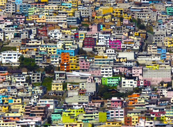
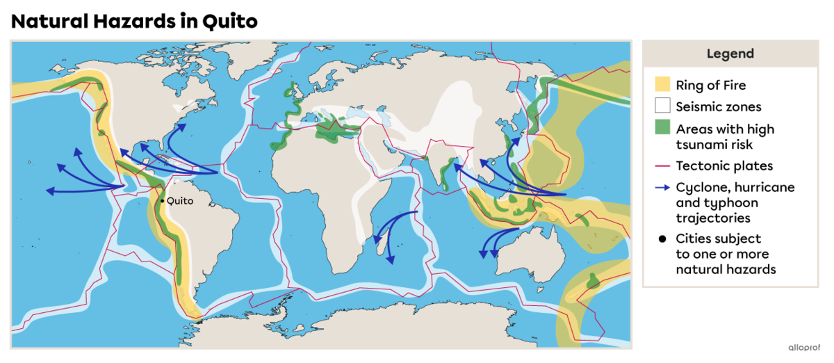
Quito is the capital of Ecuador. This country is located on the west coast of South America. The city is located to the north, in the Andes mountains, at more than 2800 metres altitude[1]. The city centre developed in a valley and then spread up the slopes of the surrounding mountains and at the base of the Pichincha volcano.
The ash that has accumulated in the valley where Quito is located has made the soil very fertile and, as a result, agriculture has become a major activity around the city. Textile and pharmaceutical manufacturing are also important economic activities in the region.
-
Altitude refers to the elevation (height) of a place in relation to sea level.
-
A valley is a hollow located between two elevated zones (mountains).
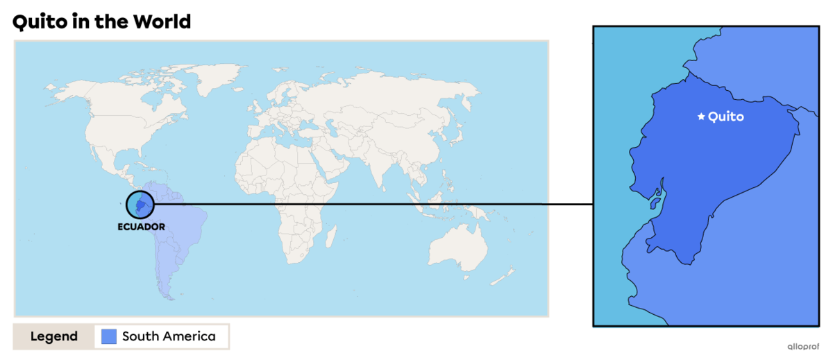
Quito was founded in 1534 on the site of an existing city. It is the oldest capital in South America and is listed as a heritage city on UNESCO’s World Heritage List.
Quito’s location comes with the risk of volcanic eruption or an earthquake. The city is also at risk for floods and landslides, consequences of volcanic eruptions and earthquakes.
In 2017, the city of Quito had a population of 2 644 145 inhabitants[2]. The area of the city is approximately 4230 km2[3], therefore, its population density is 625 inhabitants/km2.
By comparison, the city of Montreal has a population density of 912 inhabitants/km2[4].
Population density refers to the average number of individuals living in a given area. It measures the number of inhabitants per square kilometre (inhabitants/km2).
Quito is located in Ecuador, a developing country. In 2021, the gross domestic product per inhabitant (GDP/inhabitant) was $5,965.10[5].
By comparison, for the same year, the GDP/inhabitant in Canada was $51,987.90[6].
Quito has undergone very rapid urbanization. The population and city sprawl has doubled since 1980. Most of the people who came to live in Quito were poor peasants in search of work. They had little money, prompting the development of many slums. Today, one inhabitant out of three lives in a slum[7], and nearly 30% of the population of Quito lives in poverty[8].
-
A developing country is a country where the population generally has a low standard of living.
-
Gross domestic product (GDP) is used to estimate a country’s wealth by calculating the value of the goods and services it produces in one year.
-
Urbanization refers to population growth and the development of an urban territory.
-
A slum is a living area close to a metropolis where very disadvantaged people live. Slums have few or no basic services (water, sewers, electricity, etc.).
A natural hazard is a danger related to a natural phenomenon.
The city of Quito is located very close to Guagua Pichincha, an active volcano. There are also other volcanoes nearby, including Cotopaxi.
Guagua Pichincha
This volcano, dormant since 1660, became active again in the 1980s, but did not erupt until fall 1999[9]. The eruption generated large clouds of ash that fell in the vicinity of the volcano, including in Quito. However, the city was not affected by the lava and mud flows from the volcano. A dome blocked the magma from being ejected from the volcano. However, this dome is now broken and will no longer protect the city.
The dangers of a future eruption for Quito are ash clouds, ash rain, pyroclastic flows, landslides and destructive mudflows called “lahars”.
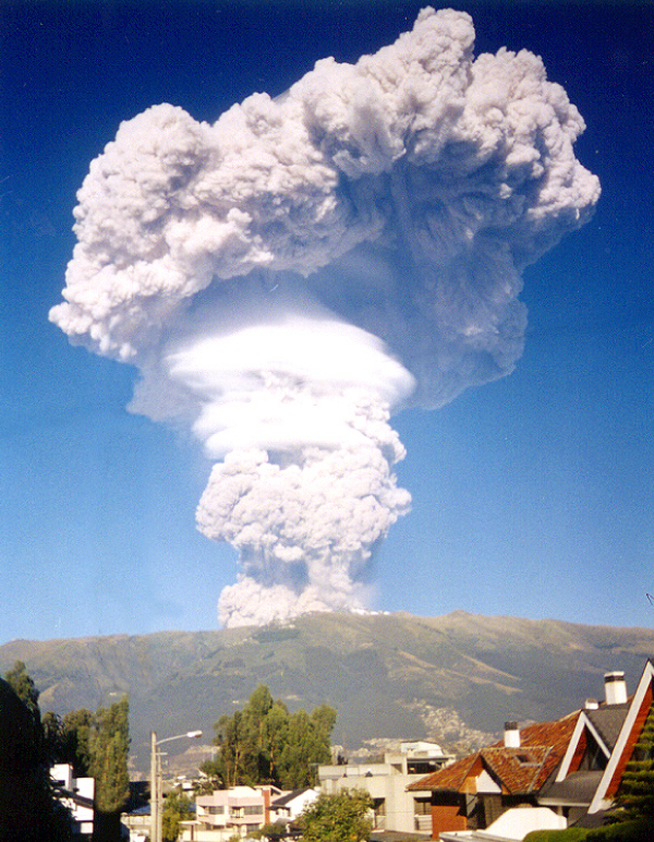
Source: Volcán Guagua Pichincha durante su erupción - panoramio [Photograph], Ciencia1.com, 2007, Wikimedia Commons, (URL). CC BY 3.0[10].
-
A lahar is a mudflow made up of ash, other volcanic debris and water.
-
A pyroclastic flow is made up of volcanic gases, water vapour and solid elements, such as volcanic rocks, that flow or fall down the slopes of a volcano at great speed.
To find out more about pyroclastic flows, check out Pyroclastic Flow.
Cotopaxi
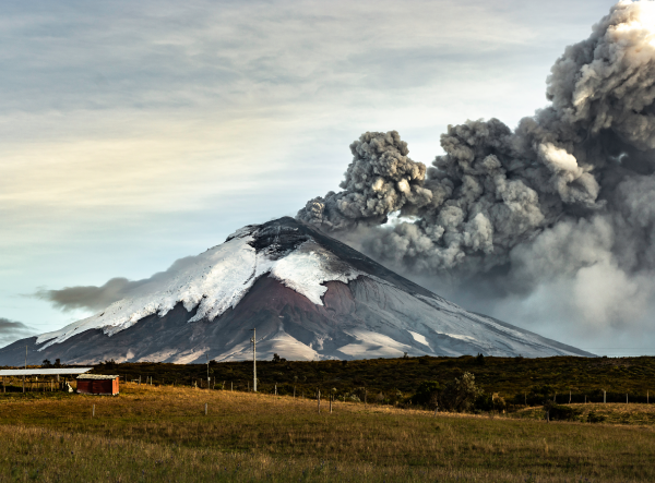
This volcano is located approximately 45 km from the city of Quito[11]. It is further than Guagua Pichincha, but still poses a major risk for Quito and the people who live there.
In 2015, Cotopaxi woke up, spewing smoke several kilometres into the air. Preventive evacuations were carried out and the eruption did not cause major damage. The ash clouds that hung in the air for days and weeks damaged the surrounding agricultural land and harmed people who breathed in this ash. In December 2022, the volcano erupted again, ejecting gas and ash into the atmosphere. The winds carried the ash as far as areas south of Quito, but the ash clouds were small and did not cause major damage.
While the eruptions of 2015 and 2022 did not have many consequences for Quito, the city is not protected from future eruptions. The pyroclastic flows from Cotopaxi could easily reach Quito, causing many deaths and significant material damage.
This eruption created a lahar that destroyed everything in its path. Flows travelled more than 100 km to the east and west of the volcano, causing many casualties[12]. Another eruption of this volcano would put many people’s lives in danger since the territory surrounding the volcano is more populated than it was in 1877.
The city of Quito has had many earthquakes in the past and continues to be at greater risk of earthquakes because it is located in a zone where the Nazca and South American tectonic plates are located. Some of these earthquakes caused major damage and many casualties, while others were felt, but did not lead to any serious damage.
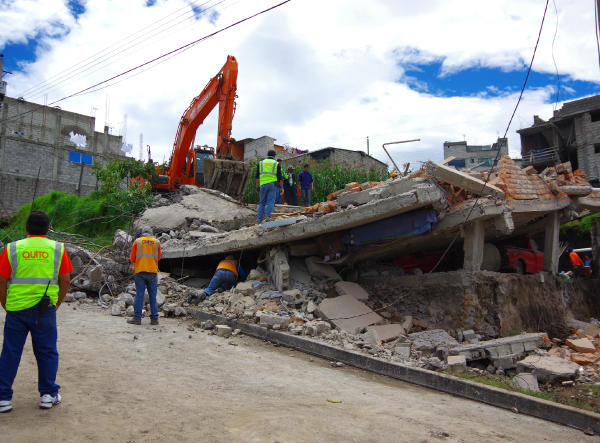
In April 2016, an earthquake damaged many buildings.
Source: Fotos593, Shutterstock.com
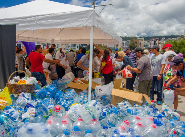
Help is being offered to those affected by the earthquake in April of 2016.
Source: Fotos593, Shutterstock.com
| Year | Magnitude | Impacts |
|---|---|---|
| 1987 | 6.9 |
There were an estimated 4000 victims[7]. Many deaths were caused by landslides, mudslides and floods. There were millions of dollars of material damage. |
| 2014 | 5.1 | The earthquake killed four people and injured a dozen others[7]. |
| 2016 | 7.8 | According to official assessments, there were 673 deaths and 6274 injuries, with more than $3.3 billion in material damage[13]. |
| 2017 | 5.2 | The earthquake did not cause any deaths, nor major damage. |
| 2019 | 7.5 | The earthquake did not cause any deaths, and there was only minor damage. |
| 2021 | 4.5 | The earthquake did not cause any deaths, and there was only minor damage. |
Quito is at risk for floods and landslides, increased by the city’s urbanization. The city is built in a valley and along the slopes of a volcano that has quebradas, which are naturally formed ravines to drain the water. Because the city urbanized quickly, many quebradas were filled in with earth in order to build roads and houses, disrupting the natural drainage of soil.
The city’s drainage is inadequate during heavy rainfall. The water accumulates in the streets and certain low-lying areas. These frequent floods do not usually cause major damage, but are still disruptive to residents.
The poor soil drainage sometimes leads to serious consequences, such as landslides that sweep away sections of roads and buildings.
Draining is the evacuation of water from land that is flooded or too wet. This can occur naturally or through human action.
Towards the end of January 2022, a large quantity of rain fell on the city of Quito, the most in almost 20 years. The rain caused flooding in the city as well as a landslide on the slopes of the Pichincha volcano.
These events caused a lot of damage to the city’s buildings and electrical grid. Eight houses and several cars were swept away. Residents had to deal with the mud, rocks and debris that covered parts of the city. According to final assessments, the natural disaster caused 28 deaths and 52 injuries[14].
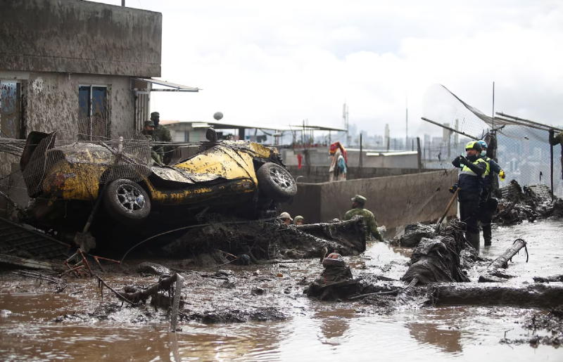
Teams of rescue workers searched houses and streets in the days following the heavy rainfall.
Source: Homes and streets were covered by mud on Feb. 1. [Photograph], Jonatan Rosas /Reuters, February 2 2022, The Washington Post, (URL). All rights reserved*[15]
A natural disaster is a natural phenomenon that results in material damage (to buildings, roads, etc.) and human victims (injuries, loss of life, etc.).
Quito has few means and preventive measures to deal with all of the natural hazards that threaten it. Here are the different preventive measures currently in place for each hazard.
| Natural disaster | Preventive measure |
|---|---|
|
Volcanic eruptions |
|
|
Earthquakes |
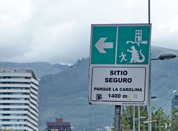
Certain zones are identified as safe during earthquakes and can provide refuge for the population. Signs like this one indicate the location of these safe zones.
Sign Indicating a Safe Zone in Quito Many of these signs were humorously modified after they were put up. On this one, someone added a sticker of Godzilla. Source: Angela N Perryman, Shutterstock.com |
|
Floods and landslides |
Following the floods in 2022, officials started working on a plan to reduce the impacts of natural hazards. |
Does the city of Quito have preventive measures in place?
The city of Quito has practically no evacuation or preventive plan in place. The only prevention carried out by officials is to advise residents to keep emergency kits at home in the event of a natural disaster (food, water, flashlight, mask, radio).
Why does Quito not have an evacuation and prevention plan?
A number of factors explain the lack of natural disaster preventive measures in Quito. In general, the high increase in the urban population combined with a lack of land-use policies has meant that people have settled in at-risk zones. However, Quito is slowly starting to put in place urban organization strategies with the goal of being better prepared in the event of a natural disaster. The problem is that the country’s government does not have the tools in place to efficiently organize the territory to protect it from natural disasters.
Does Quito want to improve its preventive measures?
Despite the lack of tools, Ecuador would like to improve its natural hazard preventive measures, which has led to the creation of the Risk Management Technical Secretariat.
How can natural hazard prevention be improved in Quito?
Establishing preventive measures in Quito and elsewhere in the country will not be easy. Because of decades of delay, important changes will have to be made in:
-
the urban organization of the city
-
the building codes
-
the reinforcement of existing infrastructure
-
the protection of the areas most vulnerable during volcanic eruptions
What does Quito want to put in place to prevent floods and landslides?
Due to the high risk of floods and landslides, one of the main priorities is to reduce these risks and establish adequate action plans. Quito’s city officials want to put in place a risk reduction plan, among others, by inspecting and improving water drainage infrastructure.
What does Quito want to put in place to prepare for earthquakes?
One of the priorities is to identify important buildings (such as schools and hospitals) and infrastructure (such as the energy system), and then take measures to reinforce and better protect them.
What role does international aid have to play in managing hazards in Quito?
The city of Quito and Ecuador in general depend a lot on humanitarian aid to put in place effective preventive measures and offer assistance following a natural disaster.
To access the rest of the unit, you can consult the following concept sheets.
- Oviedo, G. (1999, November 27). Volcano covers Quito in white ash. The Guardian. https://www.theguardian.com/world/1999/nov/27/10.
- Instituto nacional de estadistica y censos. (2017, December 5). Tras las cifras de Quito. Gouvernement de la République de l’Équateur.
- Centro Iberoamericano de Desarrollo Estratégico Urbano. (n.d.). Quito. https://www.cideu.org/miembro/quito/
- Ministère des Transports. (2022). Région métropolitaine de Montréal. Gouvernement du Québec. https://www.transports.gouv.qc.ca/fr/ministere/organisation/organisation-territoriale/cmm/Pages/region-metropolitaine.aspx
- La Banque mondiale. (n.d.). Équateur. https://donnees.banquemondiale.org/pays/equateur
- La Banque mondiale. (n.d.). Canada. https://donnees.banquemondiale.org/pays/canada?view=chart
- Boisvert, C., Roy-Cadieux, F., Krysztofiak, V., Poulou-Gallet, C., Riendeau, J. et Ste-Marie, P. (2015). Espace Temps - 1re secondaire [knowledge and activity book]. ERPI.
- oppla. (n.d.). Quito: Urban Agriculture as Nature Based Solution for facing Climate Change and Food Sovereignty. https://oppla.eu/casestudy/23366
- Futura. (2004, November 24). La ville de Quito et le Guagua Pichincha. https://www.futura-sciences.com/planete/dossiers/volcanologie-colosses-equateur-472/page/4/
- Ciencia1.com. (2007). Volcán Guagua Pichincha durante su erupción - panoramio [Photograph]. Wikimedia Commons. https://commons.wikimedia.org/wiki/File:Volc%C3%A1n_Guagua_Pichincha_durante_su_erupci%C3%B3n_-_panoramio.jpg
- Agence France-Presse. (2015, August 17). Plus de 325 000 personnes menacées par l’éruption du Cotopaxi. Le Journal de Montréal. https://www.journaldemontreal.com/2015/08/17/plus-de-325-000-personnes-menacees-par-leruption-du-cotopaxi
- The Editors of Encyclopaedia Britannica. (n.d.). Cotopaxi. Dans Britannica. https://www.britannica.com/place/Cotopaxi
- Agence France-Presse. (2022, February 7). L’Équateur secoué par un séisme de magnitude 5,2. La Presse. https://www.lapresse.ca/international/amerique-latine/201711/17/01-5143938-lequateur-secoue-par-un-seisme-de-magnitude-52.php
- Le Monde avec AFP. (2022, February 7). Équateur : le bilan des inondations à Quito s’alourdit à 28 morts et 52 blessés. Le Monde. https://www.lemonde.fr/planete/article/2022/02/07/equateur-le-bilan-des-inondations-a-quito-s-alourdit-a-28-morts-et-52-blesses_6112591_3244.html
- Jonatan Rosas /Reuters. (2022, February 2). Homes and streets were covered by mud on Feb. 1. [Photographie]. The Washington Post. https://www.washingtonpost.com/world/2022/02/02/ecuador-landslide-quito-flooding-rain/. *Content used by Alloprof in compliance with the Copyright Act in the context of fair use for educational purposes. [https://laws-lois.justice.gc.ca/fra/lois/c-42/page-9.html].
