To access the other sheets in the Tools in Geography unit, consult the See Also section.
Geographical coordinates allow us to locate a place precisely on Earth. We manage to identify these coordinates thanks to the imaginary lines that separate the planet. These lines are called parallels and meridians.
- The parallels are imaginary horizontal lines parallel to the equator that circle the Earth.
-
The equator, also called the equatorial line, is the parallel that separates the Earth into two hemispheres: the Northern Hemisphere and the Southern Hemisphere. It corresponds to latitude 0.
Parallels are used to determine latitude, the north-south position of a location relative to the equator. For this reason, parallels are also called the latitudes.
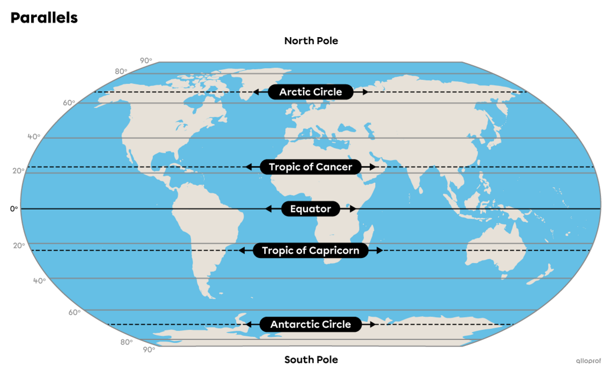
In fact, it was ancient scientists who named these lines around 2 000 years ago. At that time, in the Northern Hemisphere, the Sun was in the constellation of Cancer during the summer solstice (June 21) and in the constellation of Capricorn during the winter solstice (December 21).
-
The latitude is the position of a place in relation to the equator. Latitude is expressed in degrees.
-
A hemisphere represents one half of the globe, separated either by the equator (Northern and Southern hemispheres) or by the Greenwich meridian (Eastern and Western hemispheres).
-
The meridians are imaginary vertical lines that connect the two poles.
-
The Greenwich meridian is the meridian that separates the Earth into two hemispheres, the Eastern and the Western. It corresponds to the degree of longitude 0. It is sometimes called the origin meridian or the zero meridian.
Meridians are semicircles connecting the two poles. The closer you get to the poles, the smaller the distance between the meridians.Meridians in the Eastern Hemisphere are graduated from 0 to 180 degrees E. Those in the Western Hemisphere are graduated from 0 to 180 degrees W.
Meridians are used to indicate longitude, i.e. the east-west position of a location in relation to the Greenwich meridian.
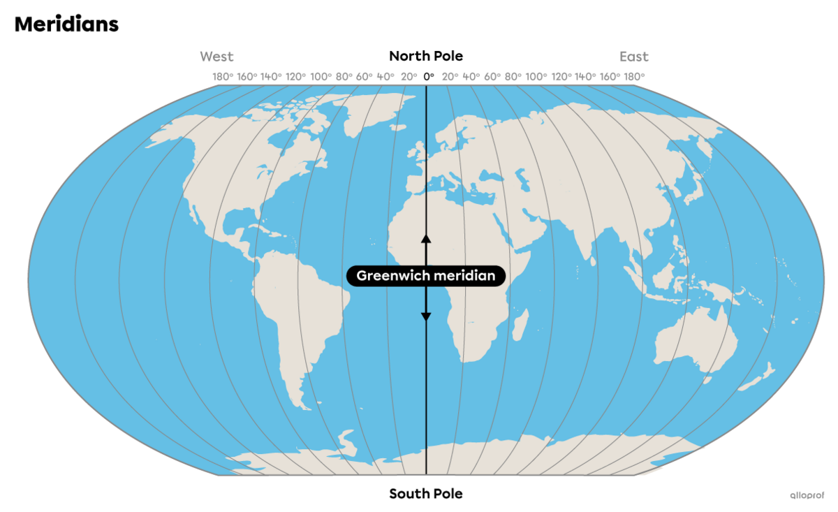
The Greenwich meridian takes its name from the fact that it runs through Greenwich, a suburb of London. It was at an international conference in 1884 in Washington that 24 countries decided to adopt the Greenwich meridian as their prime meridian. It separates the Earth from east to west and is the starting point for time zones.
Today, it's possible to see the Greenwich meridian at the Royal Greenwich Observatory, which was built in 1675.
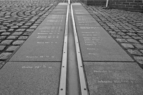
Different locations around the world are identified along the Greenwich meridian with their degree of latitude in relation to the prime meridian.
Source : Giacomo Baudazzi, Shutterstock.com
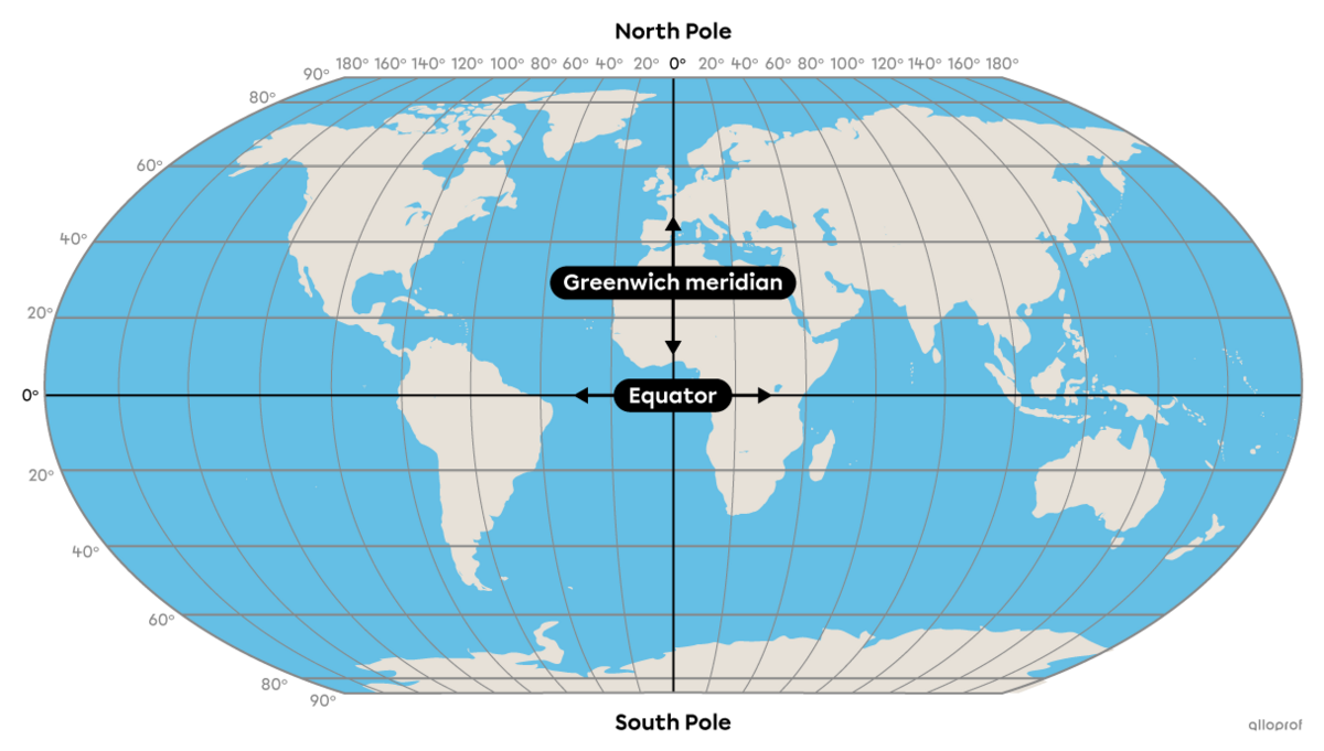
Geographical coordinates correspond to the latitude and longitude of a location. They are always read with the degree of latitude (north-south position), then with the degree of longitude (east-west position).
It's thanks to geographical coordinates that GPS and navigation systems are able to find someone's precise location on Earth.
Meridians are perpendicular to parallels. So, to find the geographical coordinates of a specific place on the planet, you need to find its latitude (parallel) and longitude (meridian). As each parallel and meridian is associated with a degree, we can precisely locate any place on the planet.
Geographical coordinates can be written as degrees, minutes and seconds (DMS), e.g., 41° 23' 45" N.
As seen above, parallels and meridians are divided into degrees. Each degree of latitude and longitude is divided into 60 units called minutes. Then, each minute is divided into 60 smaller units, called seconds. This division makes it possible to locate all locations on Earth very precisely.
Be careful, even though we use the terms minute and second, we're not calculating time, but rather distance.
The geographical coordinates of the Eiffel Tower are 48° 51' 30.132" N 2° 17' 40.132" E.
The coordinate 48° 51' 30.132" N reads: "Forty-eight degrees, fifty-one minutes, thirty, decimal, one hundred and thirty-two seconds north latitude."
The coordinate 2° 17' 40.132" E reads: "Two degrees, seventeen minutes forty, decimal, one hundred and thirty-two seconds east longitude."

Sometimes the letter W is used to indicate west instead of O. The aim is to avoid confusion with the number zero.
For more information, please consult the following concept sheets.
To access the rest of the unit, consult the Tools in Geography concept sheet.