To access the other concept sheets in the Cities Subject to Natural Hazards unit, check out the See Also section.
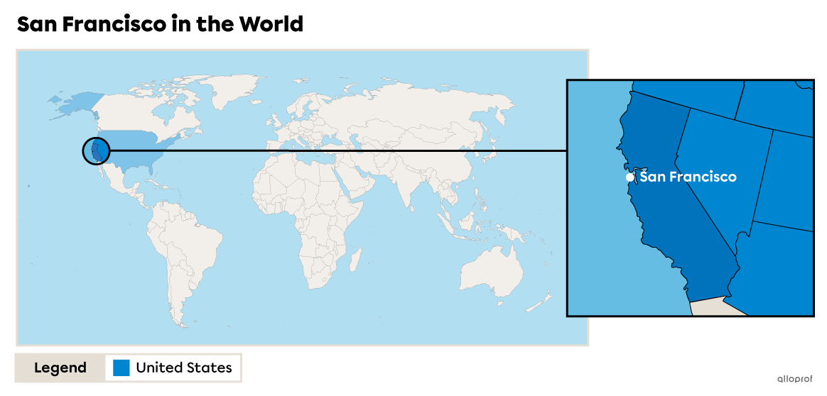
The city of San Francisco is in the State of California, on the west coast of the United States. The city is located in a bay called the San Francisco Bay. The San Francisco Bay Area refers to a group of cities located in this geographic location, such as San Jose and Oakland.
A bay is a body of water partially enclosed by land but with access to a sea or a lake. A bay is smaller than a gulf.
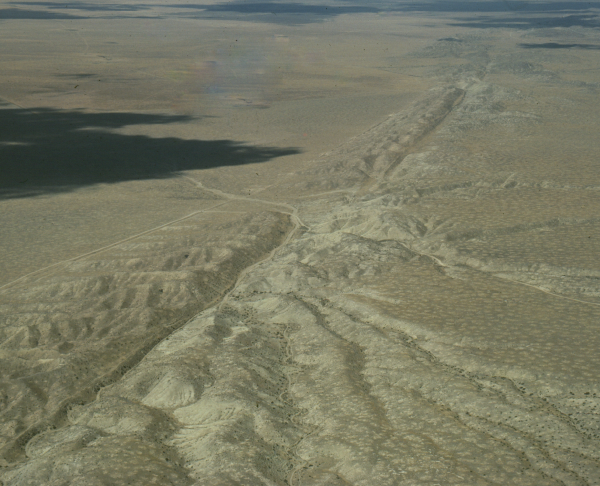
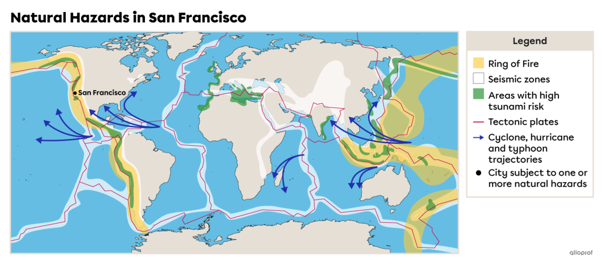
San Francisco is located on the boundary of two tectonic plates: the Pacific Plate and the North American Plate. The 1300-km long San Andreas Fault marks the boundary between these two plates[1]. Each year, this fault shifts approximately 5 cm due to the movement of the plates[2]. Consequently, the city is in a high-risk earthquake zone.
The possibility of earthquakes also puts the city at risk of tsunamis, floods and landslides.
A fault is a break in the Earth’s crust.
In 2021, San Francisco’s population was 815 201 inhabitants, making it the fourth most populous city in the State of California[3]. The area of the city is 120 km2[4], therefore its population density is 6793 inhabitants/km2.
In comparison, the city of Montreal has a population density of 912 inhabitants/km2[5].
The high population density of the city of San Francisco puts it at greater risk in the event of a natural disaster, with greater human and material consequences.
Population density refers to the average number of individuals living in a given area. It measures the number of inhabitants per square kilometre (inhabitants/km2).
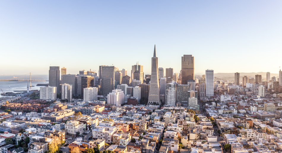
Source: zhu difeng, Shutterstock.com
San Francisco is located in the United States, a developed country. The gross domestic product per inhabitant (GDP/inhabitant) in the United States is $69,287.54, one of the highest GDP/inhabitant in the world[6]. The population generally has a good standard of living.
Consequently, San Francisco has the resources and financial means needed to put in place natural hazard preventive measures. These measures do not stop natural hazards, but they can reduce their negative effects. To find out more about preventive measures, check out the preventive measures section.
-
A developed country is an industrialized country where the population generally has a high standard of living.
-
Gross domestic product (GDP) is used to estimate a country’s wealth by calculating the value of the goods and services it produced in one year.
-
Standard of living reflects the quantity of goods and services to which a person or a population has access.
San Francisco’s geographic location exposes it to many earthquakes, due to the contact between two tectonic plates (the North American and Pacific plates) and the presence of several faults, including the San Andreas fault.
There are several earthquakes in San Francisco every year, but most of them are minor and cannot be felt. However, the city has had some very high-magnitude earthquakes in the past.
There is a very high risk that the city will be hit by another high-magnitude earthquake in the coming decades. This future earthquake is referred to as the ‘Big One’. Since the two plates are continuously moving closer to each other, the pressure on the plates is increasing. When the accumulated pressure releases, it causes a high-magnitude earthquake. This release occurs approximately every 150 to 200 years[7]. That's why experts know that an earthquake of this magnitude will occur in the next few decades. However, it is not possible to predict the exact moment.
Magnitude is the strength of an earthquake. It is measured using the Richter scale, which ranges from 1 (the weakest) to 9 (the strongest).
San Francisco has experienced several major earthquakes, including those of 1906 and 1989.
In 1906, much of the city was destroyed by an earthquake that registered a magnitude of 7.9 on the Richter scale. An estimated 3000 people were killed by the earthquake and the huge fire it caused in the city[8].
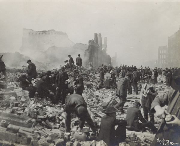
On top of dealing with the damaged infrastructure and aiding the thousands of people rendered homeless, the San Francisco authorities also had to manage people trying to commit theft.
Source: National Archives Catalog, 1906[9].
There was another severe earthquake in 1989. This one, sometimes called Loma Prieta, also caused serious damage to the city as well as the surrounding San Francisco Bay area. In the end, 63 people died, more often due to roads that collapsed, and 3800 more were injured. As many as 20 000 homes were damaged or destroyed. All in all, this earthquake caused damages upward of 6.8 billion dollars[10].
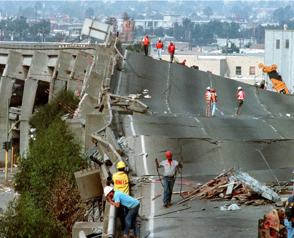
The 1989 earthquake caused part of the Nimitz Freeway to collapse. The upper level collapsed onto the lower level, killing 42 people.
Source: Forty-two people died in Oakland when the upper level of Interstate 880, also known as the Nimitz Freeway, collapsed at the Cypress Street viaduct [Photograph], Paul Sakuma/Associated Press, (n.d.), The New York Times, (URL). Rights reserved* [11]
The city of San Francisco is located in a tsunami risk zone since it is on the coast, in an area with strong earthquake activity. Since 1850, scientists have observed and recorded approximately 51 tsunamis[12].
The biggest tsunami to hit the San Francisco Bay Area was caused by a 9.2 magnitude earthquake in Alaska in 1964. The waves that reached the coast were approximately 1.2 m high[13].
The tsunamis that could affect San Francisco are classified into three different groups. These groups are based on the distance from the trigger event.
| Type of tsunami | Distance of the trigger event | Estimated time before the waves reach the coast | Risk that this occurs |
|---|---|---|---|
| Distant source | 1000 km and more | 4 h to 15 h | Moderate |
| Regional source | Less than 1000 km | 1 h to 1 h 30 min | Moderate |
| Nearby source | 100 km and less | 10 to 15 minutes | Low |
Source of the data: SF 72, s.d.[14]. |
|||
A tsunami does not always generate huge waves. It can produce smaller waves of 1 metre or very high waves of 24 metres. This depends on the strength of the submarine earthquake and its distance from the coast.
The Hunga Tonga - Hunga Ha'apai is an underwater volcano in the Pacific Ocean, close to Tonga, a country in Oceania. On January 15, 2022, it had the strongest explosion it has had since it started erupting at the end of December 2021. The explosion was so violent, it was heard in Alaska, more than 9000 km away. It triggered a tsunami in the Pacific Ocean that reached the coasts of Japan, the United States, Chile and Peru, among others[15].
The National Weather Service issued a tsunami warning for the city of San Francisco and other cities along the west coast of the United States. The waves, which measured between 30 and 60 cm, were powerful enough to flood the parking lot in a port in Santa Cruz and cause damage to infrastructure along the water’s edge. The beaches and wharfs were evacuated and closed[16].
Because the trigger event for the tsunami was far away, approximately 8300 km from the city, officials had time to take the necessary measures to warn and protect the populations at risk.
The Hunga Tonga-Hunga Ha'apai explosion was the biggest in several decades. It created an ash column that was more than 30 km high and spread hundreds of kilometres[17].
Several places were buried in ash. The capital of Tonga was covered in two centimetres of ash, which contaminated the water and food supplies.
The volcanic eruption also generated 117 tsunamis in the Pacific Ocean. Unlike the waves that reached the Californian coast, those that hit Tonga were approximately 15 metres high[18].
Floods in San Francisco are mostly caused by heavy rainfall. The city is not able to drain the water fast enough and water accumulates, causing a number of problems.
In October 2021, the west coast of the United States, including San Francisco, was hit by violent storms. In one day, the city received more than 100 mm of water[19]. The heavy precipitation caused flooding, especially in the San Francisco Bay Area.
The city of San Francisco is at high risk of landslides, mostly caused by heavy rainfall. Landslides are also caused by earthquakes and can be deep or shallow. Both can have serious consequences for the population.
On February 6, 1942, there was a landslide on Mount Davidson in San Francisco. The region had been hit by several days of rain. A mass of land, 1.83-metres (6-feet) deep, detached from the mountain and swept several houses away[20]. This was caused by the poor real estate practices of a developer, in addition to heavy rainfall.
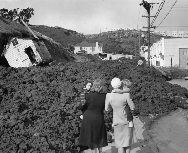
Source: View north on Foerster Street after mudslide, February 7, 1942 [Photograph], (1942), Open SF History, (URL). All rights reserved*[20]
In general, the city of San Francisco is well prepared for the various natural disasters that can occur on its territory. Here are some examples of the disaster prevention measures put in place.
| Prevention measure | Example |
|---|---|
|
The population is informed of the risks and the measures to take before, during and after a natural disaster. |
The city of San Francisco makes many resources available to citizens to fully inform them of the possible consequences of an earthquake. These resources also guide residents in putting in place an emergency plan so that they can be well prepared during a disaster. |
|
Residents are sent alerts to warn them of a coming disaster. |
Residents and visitors can sign up for AlertSF to receive alerts for various emergencies. |
|
Maps of at-risk zones are made available to the population. |
California’s Department of Conservation has made a map available to residents which indicates tsunami risk zones. Citizens can consult it to see if their home or workplace is in this zone and to find out where to go in the event of a tsunami. |
|
Infrastructures are built to reduce the impact of natural disasters. |
Dyke walls can be built to reduce the impact of landslides in areas where slopes are steep. |
|
Assistance programs for the population. |
A program was put in place to help owners in at-risk zones prepare their house in the event of a flood, such as installing waterproof exterior doors. |
The city of San Francisco is at a very high risk of earthquakes. Experts predict that the Big One has a 62% chance of occurring by 2032[7]. As a result, San Francisco has already put in place several measures to reduce the consequences of future earthquakes. Here are a few examples of these measures.
-
The city of San Francisco reinforced the infrastructure that transports drinking water from Yosemite Park to the city.
-
An earthquake-resistant construction code is in place.
-
Guides have been prepared informing the population of what to do before, during and after an earthquake.
-
The Golden Gate Bridge has been renovated to resist a future high-magnitude earthquake.
This short documentary draws a portrait of the 1989 earthquake and the measures put in place since then to be better prepared for a future earthquake.
Even though San Francisco is taking numerous measures to strengthen infrastructure, such as schools, hospitals and highways, certain buildings are sometimes less prioritized than others in prevention plans. This is the case of skyscrapers.
In the last two decades, the city of San Francisco has permitted the construction of more and more skyscrapers. These buildings are often built very close to each other and are getting taller in order to try to resolve San Francisco’s serious housing crisis. In 2018, the city already had 160 skyscrapers that were more that 73 metres high, with over a dozen others planned or in construction[21]. Building experts are increasingly realizing that skyscrapers are not as safe and solid as was once believed.
The Millennium Tower is a 58-storey skyscraper in downtown San Francisco. Its construction was completed in 2009. In 2016, reports revealed that the building had sunk 45 cm into the ground and was leaning 36 cm towards the building beside it[21], making it more at risk of collapse during an earthquake.
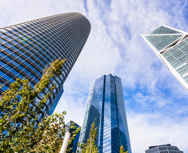
Source: Sundry Photography, Shutterstock.com
The discoveries made about the Millennium Tower led to demands for a reassessment of earthquake risks related to skyscrapers. Attention was focused on improving building standards. Here are a few examples of the standards that could be improved.
-
Standards for solidity are the same for a 5-storey building and a 50-storey building.
-
It is important to accurately calculate the real resistance of skyscrapers to earthquakes, not only because earthquakes are unpredictable, but also considering that buildings in large cities are not often tested by high-magnitude earthquakes.
-
Past earthquakes have revealed defects in previous construction techniques:
-
The Northridge earthquake in 1994 in Los Angeles revealed that a very common welding technique does not resist earthquakes. Several buildings in San Francisco that were built using this technique have not yet been updated to implement the new standards, meaning there is additional recognized risk.
-
-
Construction standards require buildings to be collapse-proof. However, they do not require that they be inhabitable after an earthquake. Therefore, even if skyscrapers do not collapse, thousands of people could find themselves on the street after an earthquake because they couldn’t return to their home.
San Francisco’s skyscrapers are not as solid as they could be and are often built very close to each other, which significantly increases the risk of damage during earthquakes.
In addition to inadequate building standards, the location of several skyscrapers puts them in danger. More than 100 of them are located in a zone where the soil is at high risk of liquefying during an earthquake.
Part of the city of San Francisco is built on former marshland and areas that were once covered in water. In order to expand the city, these locations were filled in with soil so that new infrastructure could be built.
These lands, called embankments, are not very earthquake-resistant due to their composition that puts them at risk of liquefying.
Soil liquefaction is a phenomenon during which the soil behaves like a liquid. This means that the land can no longer support infrastructures built on it, which could cause serious damage.

This San Francisco district is mostly built in a zone at high risk of soil liquefaction. The buildings, including several skyscrapers, could be seriously damaged during an earthquake.
Source: The skyline of downtown San Francisco [Photograph], GyozaDumpling, July 14, 2019, Wikimedia commons, (URL). CC BY-SA 4.0[22]
This video explains the phenomenon of liquefaction in greater detail.
To access the rest of the unit, you can consult the following concept sheets.
- The editors of the Britannic encyclopedia. (2022, September 8). San Andreas Fault. Britannica. https://www.britannica.com/place/San-Andreas-Fault
- Boisvert, C., Roy-Cadieux, F., Krysztofiak, V., Poulou-Gallet, C., Riendeau, J. et Ste-Marie, P. (2015). Espace Temps - 2e secondaire [cahier de savoirs et d’activités]. ERPI.
- Data Commons. (n.d.). San Francisco. https://datacommons.org/place/geoId/0667000?utm_medium=explore&mprop=count&popt=Person&hl=fr
- Lamott, K. (2022, November 8). San Francisco. Dans Britannica. https://www.britannica.com/place/San-Francisco-California
- Ministère des Transports. (2022). Région métropolitaine de Montréal. Gouvernement du Québec. https://www.transports.gouv.qc.ca/fr/ministere/organisation/organisation-territoriale/cmm/Pages/region-metropolitaine.aspx
- La Banque mondiale. (2021). PIB par habitant ($ US courants) - United States. https://donnees.banquemondiale.org/indicator/NY.GDP.PCAP.CD?end=2021&locations=US&start=1960&view=chart
- Lacaze, J. (2021, August 7). Californie : quand aura lieu le Big One?. National Geographic. https://www.nationalgeographic.fr/sciences/2021/08/californie-quand-aura-lieu-le-big-one
- The U.S. National Archives and Records Administration. (2020, September 30). San Francisco Earthquake, 1906. https://www.archives.gov/legislative/features/sf
- National Archives Catalog. (1906). Photograph of Souvenir Hunters After the 1906 San Francisco Earthquake. https://catalog.archives.gov/id/2127316
- California Department of Conservation. (n.d.). The 1989 Loma Prieta Earthquake. https://www.conservation.ca.gov/cgs/earthquakes/loma-prieta
- Paul Sakuma/Associated Press. (n.d.). Forty-two people died in Oakland when the upper level of Interstate 880, also known as the Nimitz Freeway, collapsed at the Cypress Street viaduct [Photograph]. The New York Times. (URL). *Content used by Alloprof in compliance with the Copyright Act in the context of fair use for educational purposes. [https://laws-lois.justice.gc.ca/fra/lois/c-42/page-9.html].
- Dengler, L., Borrero, J., Patton, J. (2004, December). Tsunami Hazards in San Francisco Bay. The SAO/NASA Astrophysics Data System. https://ui.adsabs.harvard.edu/abs/2004AGUFMOS23D1354D/abstract
- Varner, J. et Allen-Price, O. (2017, 15 juin). What Would Really Happen if a Tsunami Hit the Bay Area?. KQED. https://www.kqed.org/news/10628782/what-would-really-happen-if-a-tsunami-hit-san-francisco
- SF 72. (s.d.). Tsunamis. https://www.sf72.org/hazard/tsunamis
- Agence France-Presse. (2022, January 17). Iles Tonga : l’éruption d’un volcan sous-marin à la source du tsunami. Le Journal de Montréal. https://www.journaldemontreal.com/2022/01/17/iles-tonga--leruption-dun-volcan-sous-marin-a-la-source-du-tsunami
- Graff, A. (2022, January 15). Tsunami advisory issued for SF Bay Area coast after volcanic eruption. SFGATE. https://www.sfgate.com/bayarea/article/Tsunami-advisory-San-Francisco-Bay-Area-Tonga-16777945.php
- Agence France-Presse. (2022, January 18). Des images montrent les îles Tonga dévastées après une éruption et un tsunami. Radio-Canada. https://ici.radio-canada.ca/nouvelle/1855261/tonga-iles-eruption-tsunami-devastation-dommages
- Radio-Canada Info. (2022, February 16). Découverte | Le volcan Hunga Tonga et ses tsunamis imprévisibles [vidéo]. https://www.youtube.com/watch?v=UhSkAxdJmEM
- Weather Spark. (2021, October 24). October 24, 2021 Weather History in San Francisco. https://weatherspark.com/h/d/557/2021/10/24/Historical-Weather-on-Sunday-October-24-2021-in-San-Francisco-California-United-States#Figures-PrecipitationProbability
- Woods, A. (n.d.). Mt. Davidson Mudslide: A Closer Look. OpenSFHistory. https://www.opensfhistory.org/osfhcrucible/2020/02/08/mt-davidson-mudslide-a-closer-look/
- Fuller, T., Singhvi, A. et Williams, J. (2018, April 17). San Francisco’s Big Seismic Gamble. The New York Times. https://www.nytimes.com/interactive/2018/04/17/us/san-francisco-earthquake-seismic-gamble.html
- GyozaDumpling. (2019, July 14). The skyline of downtown San Francisco [Photographie]. Wikimedia commons. (URL). CC BY-SA 4.0
