To access the other concept sheets in the Cities Subject to Natural Hazards unit, check out the See Also section.
Not all of the world’s cities are subject to natural hazards. For those that are, there are several levels of hazard. Three factors can explain why one city could be more at risk than another:
A natural hazard is a danger related to a natural phenomenon.
Not all cities are subject to the same natural hazards since natural phenomena do not occur everywhere on the planet. For example, earthquake activity mostly occurs along tectonic plates, and most volcanoes are located along the Ring of Fire. Consequently, a city that is not located along the Ring of Fire or is not close to a tectonic plate boundary will not be subject to the risk of earthquakes or volcanic eruptions.
-
A natural phenomenon is an event that occurs in nature, without any human intervention. This could be an earthquake, hurricane, aurora borealis, etc.
-
Tectonic plates are pieces of the Earth’s crust that can move away from each other, rub against each other or collide with each other. The continents and oceans sit on tectonic plates.
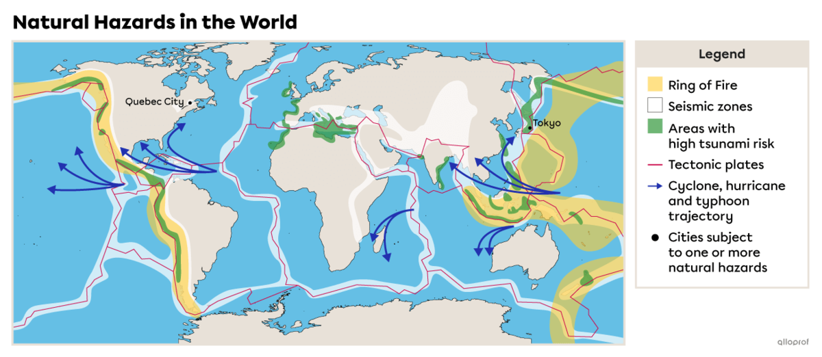
Tokyo is a city subject to many natural hazards due to its location because it is:
-
near a tectonic plate boundary and, therefore, is at risk of being hit by earthquakes
-
100 kilometres from Mount Fuji, which is an explosive volcano
-
on a typhoon trajectory
-
in a high-risk tsunami zone
-
in a high-risk flood zone
Quebec City is subject to very few natural hazards due to its location because it is located:
-
in an area where there is an earthquake risk, but since far from tectonic boundaries
-
in a continental climate zone with very cold winters, at risk of being hit by snow or ice storms
Since the locations of Tokyo and Quebec City are different, the two cities are not subject to the same natural hazards.
-
An earthquake is more or less violent shaking of the Earth’s crust caused by the movement of tectonic plates.
-
A cyclone is a violent storm that originates in the oceans close to the equator. It can also be referred to as a typhoon or a hurricane depending on the region where it forms.
-
A tsunami is a series of huge waves triggered in the ocean that can cause major damage to inhabited areas along the coast.
Why are so many cities built and developed in areas with many natural hazards? Even though these are regions with a lot of instability, they can also offer many benefits.
-
Coastal zones facilitate maritime transportation and trade
-
The land around volcanoes is extremely fertile
-
Areas where there is a greater risk of hurricanes, typhoons or cyclones are also warmer and have milder climates
The term instability refers to the unpredictability and danger related to natural phenomena in a territory.
Some cities are more at risk than others due to their high population density. The damage is likely to be much greater where the population is more concentrated because more infrastructure and people can be affected.
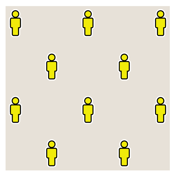
Population density refers to the average number of individuals living in a given area. It measures the number of inhabitants per square kilometre (inhabitants/km2).
 |
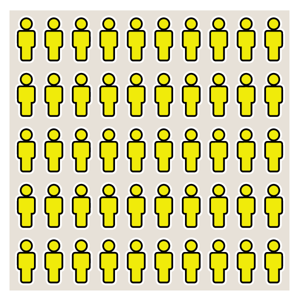 |
| The lower the density, the fewer the number of people living in a given area. | The higher the density, the greater the number of people living in a given area. |
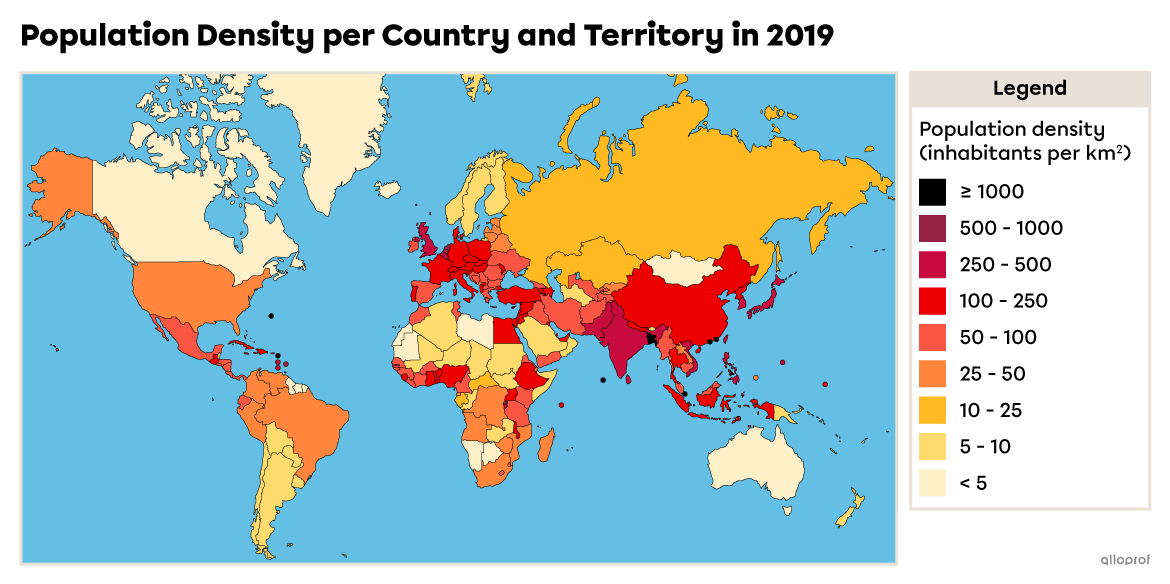
The higher the population density of a country, the greater the likelihood that the cities in that country will have a high population density.
Source: Department of Economic and Social Affairs, 2019[1].
Here is an example of two cities: Anchorage, in Alaska, in the United States (North America), and Manila, in the Philippines (Asia).
| Anchorage | Manila |
|---|---|
| 57 inhabitants/km2 | 46 846 inhabitants/km2 |
Source: Cubit Planning Inc., (2022)2 |
Source: Salita, Domingo C. (2022)3 |
Even though these two cities are not located in the same place on the planet, they are subject to similar natural hazards, such as volcanic eruptions, earthquakes, tsunamis and floods. However, their population density is different. If a 7 magnitude earthquake were to hit both cities, the damage would also be different: since Manila’s population density is much higher, the damage would be worse.
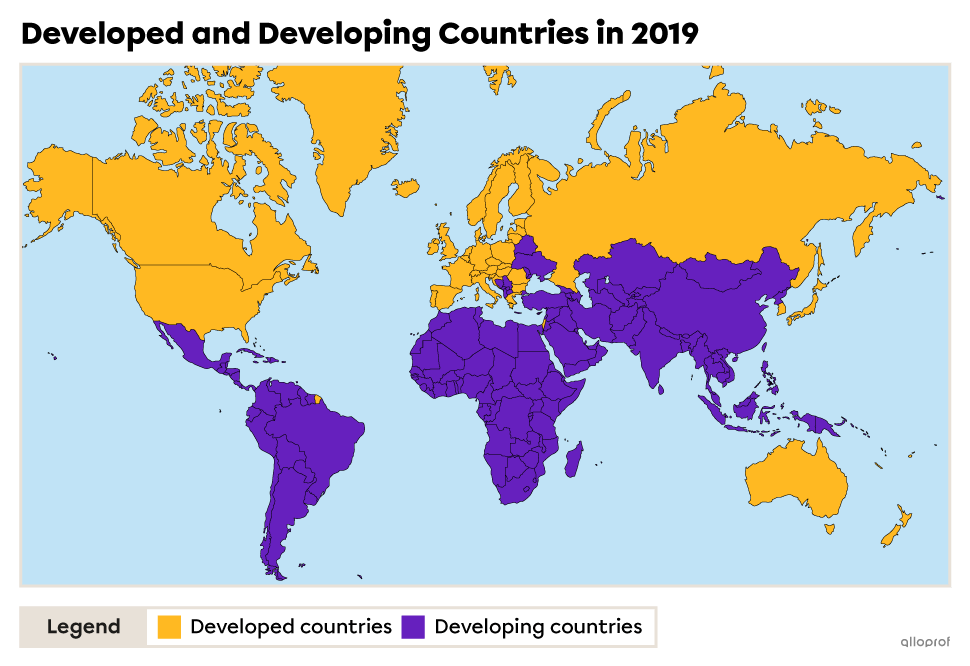
The level of development of countries creates major inequalities regarding the impact of natural hazards. Developing countries have fewer financial, material and technological resources to protect themselves. This means they are extremely vulnerable during natural disasters. Approximately 90% of the victims of natural disasters are in developing countries[4].
-
Gross domestic product (GDP) is used to estimate a country’s wealth by calculating the value of the goods and services it produced in one year.
-
A natural disaster is a natural phenomenon that causes material damage (to buildings, roads, etc.) and human victims (injuries, loss of life, etc.).
Here are two examples that illustrate the effect of a country’s level of development on the extent of human loss and material damage The first is the earthquake that hit Haiti on January 12, 2010, and the second is the earthquake and tsunami that hit Japan on March 11, 2011.
| Japan | Haiti |
|---|---|
| Developed country | Developing country |
| 9.1 magnitude earthquake Tsunami with waves that reached 16.7 m in height |
7.3 magnitude earthquake |
| 15 899 deaths, 6000 injured and 2 527 disappeared[5] | 220 000 deaths and 300 000 injured[8] |
| 470 000 homeless[6] | 1.5 million homeless[9] |
| $207 billion in damage[7] | $7.9 billion in damage[10] |
| Damage equivalent to 3.5% of the countries GDP[7] | Damage equivalent to 120% of the country’s GDP[10] |
Despite the fact that Japan was hit by a bigger magnitude earthquake along with a tsunami, fewer people died, were injured or lost their homes. This is because Japan is a developed country and, therefore, has more resources to prevent the consequences of natural disasters. An example of a prevention measure put in place in Japan is earthquake-resistant construction, which minimizes the damage caused by earthquakes. Most of the damage was caused by the tsunami that followed the earthquake.
Developing countries like Haiti do not have enough financial and technological resources to implement such effective preventive measures.
As such, a country’s level of development has a major impact on the extent of human loss and material damage caused by a natural disaster in a city or country.
An earthquake-resistant building is a building that is designed and built to withstand the ground movements of earthquakes.
To access the rest of the module, you can consult the following concept sheets.
- Department of Economic and Social Affairs. (2019). World Population Prospects 2019. United Nations. https://population.un.org/wpp/Publications/Files/WPP2019_DataBooklet.pdf
- Cubit Planning Inc. (2022) Is Anchorage the best Alaska city for your business?. Alaska Demographics. https://www.alaska-demographics.com/anchorage-demographics
- Salita, Domingo C. (2022, 5 janvier) Manila. Britannica. https://www.britannica.com/place/Manila
- Boisvert, C., Roy-Cadieux, F., Krysztofiak, V., Poulou-Gallet, C., Riendeau, J. et Ste-Marie, P. (2015). Espace Temps - 2e secondaire [cahier de savoirs et d’activités]. ERPI.
- La Presse. (2021, March 7). La catastrophe du 11 mars 2011 en chiffres. https://www.lapresse.ca/international/asie-et-oceanie/2021-03-07/japon/la-catastrophe-du-11-mars-2011-en-chiffres.php
- (n.a.). (n.d.). Séisme et tsunami au Japon. Croix-Rouge canadienne. https://www.croixrouge.ca/crc/documentsfr/japan-update-lo-res-fr.pdf
- La Presse. (2011, June 24th). Séisme au Japon : plus de 200 milliards $ de dégâts. https://www.lapresse.ca/international/dossiers/seisme-au-japon/201106/24/01-4412226-seisme-au-japon-plus-de-200-milliards-de-degats.php
- (n.a). (2022). Séisme en Haïti : retour sur notre action. Oxfam International. https://www.oxfam.org/fr/seisme-en-haiti-retour-sur-notre-action
- La Presse. (2020, January 12th). Haïti commémore le séisme de 2010 dans l’amertume. https://www.lapresse.ca/international/caraibes/2020-01-12/haiti-commemore-le-seisme-de-2010-dans-l-amertume
- La Croix. (2010, March 30th). Haïti: bilan du séisme. https://www.la-croix.com/Actualite/Monde/Haiti-bilan-du-seisme-_NG_-2010-03-30-549215